GPS - Making sense of UTM
This page will NOT serve as a description of what GPS is, what it does and how it works. That is more than adequately covered by other sites. This page will introduce an alternative to the traditional lat/long system in which to operate your GPS.
Getting the most from your receiver.
Most people tend to run their receivers in bog standard lat/long mode. This
in itself is fine, but why complicate matters? Since the removal of Selective
Availability, GPS units can boast an accuracy of something like 5m given favourable
reception conditions (lots of satellites in view). My Garmin unit regularly
gives an estimated positioning error of less than 8m whilst sat on the car dashboard
and 5m out in the open. Compare this to the days when SA was a real thorn in
the side - 100m accuracy if you were lucky. If you steadfastly use the lat long
units on your receiver, this may make you think again.
If we look at lat long, the resolution is 1/1000th of a minute or 1/10th of a second. Given that 1 minute of latitude is 1 nautical mile, or 1853 metres, using the decimal minute scale gives a resolution of just under 2 metres, and using the decimal second gives a resolution of around 3 metres. These in themselves are fine, but how do you correlate those figures to real world, understandable distances? Tell a diver to swim 27/1000th of a minute (or 1.6 seconds) in an easterly direction and you're virtually guaranteed to be met with abuse. Tell the same diver to swim 50m east and they'll (hopefully!) be fully capable of following the instruction.
OK, so what are the alternatives?
A nice unit to use (for those amongst us who're metricated) is that of
metres. The GPS has a few systems that use metres. For the UK, we have the British
Grid - usually seen on Ordnance Survey land maps - which is fine as long as
you're using the GPS within the UK and within (relatively) inshore waters. The
postional info can be readily plotted onto any OS map. This isn't really a solution
though. A much better system is that of the Universal Transvere Mercator (UTM)
Projection System.
And why should I use UTM?
Say you're out wreck hunting. You've got a charted
wreck lat/long which you want to check out. The position has been entered into
the GPS and converted to UTM. The charted postion
is now given as 30 U 0478613 5688915. Don't worry about these numbers for now,
they're explained in the next section, but the large numbers are metres. We
decide we're going to use a 100m search pattern to locate the wreck. We now
have 2 choices. We can either make East-West passes or North-South passes, and
because the GPS is in UTM mode, this is simple. We could choose the starting
point say 300m South and 300m West of the original location, 30 U 0478300 5688600.
For a North-South search, we'd keep the easting
constant (0478300) and motor North until say 5689200 (300m further north of
the charted position) shows on the GPS. At this point we then head 100m east
(30 U 0478400 5689200) then head south until hitting 5688600. At which point,
we then head a further 100m east (30 U 0478500 5688600) etc etc. The beauty
of the system comes in when a contact is made. The point of contact can be easily
marked on the GPS. If a subsequent break of contact is also recorded, this too
can be marked. The search can continue, marking makes and breaks of contact.
These co-ordinates can then be easily transferred onto paper and not only the
vessels size estimated, but also it's orientation. From this, you can pretty
much decide exactly where you want to place the shot on the wreck.
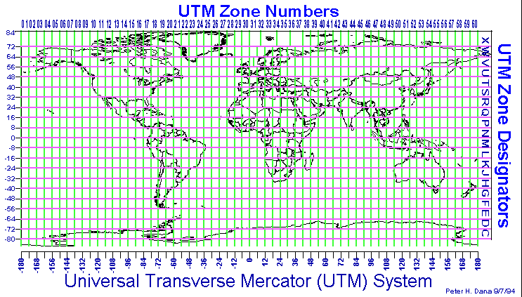
The UTM Projection System
The UTM system divides the world into 60 horizontal and 20 vertical bands, calling
each a zone. Each east-west band represents (typically
- see zones 31 & 32 V and zones 31-37 X for the obligatory exceptions) 6
degrees of longitude and is identified by the numbers 1 through 60. Zone 1 starts
at the International Date Line (180º West), with Greenwich (0º longitude) being
in Zone 31. Each zone therefore covers 6º or 360 nautical miles (approx 667km)
of horizontal distance.
The vertical north-south axis is also divided. This time it's demarked with
the use of the letters C through to X, with the exception of I and O. Consequently,
a zonal x-y can be specified. West Wales for example is covered by zone 30 U
(as is the majority of the UK).
This is only the start of the UTM reference. Following this there's a whole load of numbers. Fortunately, these are split into an X (easting) and a Y (northing) component.
UTM Eastings
The X component (the first number) represents the number of metres EAST
from the start of the zone. However, this number is known as a false easting
as the middle of the zone is always defined as 500,000m. Consequently, zero
will never be seen (each zone covers around 667,000m). The maximum and minimum
eastings obtainable for a zone at the equator are 160,000m and 834,000m - 160,000
being the start, or western most point of the zone, 834,000m being the end or
most easterly point of the zone.
UTM Northings
The second number, represents the number of metres from the equator, either
north or south.
UTM northing coordinates are measured relative to the equator. For locations
north of the equator the equator is assigned the northing value of 0 meters
North. To avoid negative numbers, locations south of the equator are made with
the equator assigned a value of 10,000,000 meters North and the number of metres
south is subtracted from this number. e.g. a location 1km south of the
equator on the Greenwich meridian would have a UTM Northing of 9,999,000.
Some UTM northing values are valid both north and south of the equator. In order
to avoid confusion the full reference needs to specify if the location is north
or south of the equator. This is accomplished by including the letter for the
latitude band.
A typical referenece as displayed on a GPS may look like this:-
30 U 0478613
UTM 5688915
The 30 U is the zone designator, the first number is the easting
for that zone, the second number the number of metres distance from the equator.
The UTM serves to remind you that the GPS is in UTM mode, and serves
no other purpose.